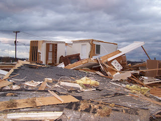
Anyways - my damage was part of a lengthy path of straight line winds that stretched in parts over a damage path of 15 miles. The last 6 miles (due east of my house) or so of that was a tornado that peaked at EF-2 strength. I consider myself very lucky.
Just for fun - this is what an EF-3 supercell tornado looks like on radar. This cell had an EF-3 (165mph winds) on the ground for about 60 miles and went very close to downtown Nashville, TN before crossing into KY (smirk). I have included one picture of the damage it caused in Monroe County, Kentucky (there were zero deaths in Monroe Co.). I hope to have more damage photos from across KY (c'mon) posted somewhere soon.


No comments:
Post a Comment